


Background
Quantitative precipitation estimate is one vital input to meteorologists, hydrologic scientists, water resources managers, and environmental legislators. Yet, accurate measurement of precipitation over the relevant space and time scales remains a challenge. Soil moisture can be seen as the trace of the precipitation and, consequently, can be useful for providing a way to estimate rainfall accumulation or at least a new constrain to rainfall algorithms.
In this context, the objective of the ‘SMOS+RAINFALL’ project is to ingest satellite soil moisture information derived from ASCAT, SMOS and SMAP into the latest state-of-the-art satellite precipitation products like those derived from the Global Precipitation Measurement mission (GPM) to enhance rainfall observation accuracy over land.
Two main approaches are considered in the project: 1) the Soil Moisture to Rain (SM2RAIN) approach which retrieves rainfall information from satellite soil moisture by inverting the soil water balance equation and then merge it with the Integrated Multi-satellitE Retrievals for GPM (IMERG) Early Run version via an Optimal Linear Interpolation approach and 2) Precipitation Inferred from Soil Moisture (PrISM) approach which is based on a particle filter data assimilation.
Key features
- Potentially availability of enhanced rainfall observations in near real time with a latency of about 1 to 3 days
- No use of ground-based observations which over data scarce regions can be very uncertain due to interpolation errors.
- Use complementary microwave-based satellite soil moisture observations as to obtain always best rainfall correction in space and time.
News
- We have updated the GPM+SM2RAIN rainfall product to the new version 1.0
The dataset can be downloaded here:
https://doi.org/10.5281/zenodo.3854817.
With respect to the previous version this new version:
1) uses IMERG-LR as GPM rainfall product.
2) is now available from 2007 to 2018 with global coverage (+/-60°) over land (0.25° spatial and daily sampling). - PrISM rainfall product
A new manuscript has been published on Remote Sensing journal (MDPI) which provides theoretical background of PRISM algorithm and its use in Africa. The study confirms the importance of satellite soil moisture observations to enhance satellite rainfall estimates especially over data scarce regions like Africa where ground-based observations are scarce. The manuscript can be accessed here
Datasets
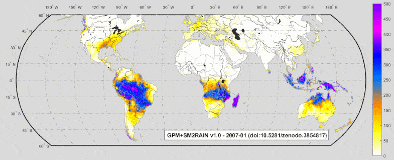
GPM+SM2RAIN v1.0 dataset is currently available here
Rainfall dataset based on the integration of IMERG Early Run of the Global Precipitation Measurement Mission (GPM) with SM2RAIN-based rainfall estimates derived from ASCAT, SMOS and SMAP L3 soil moisture products. The dataset is currently available globally +-60° (2007-2018). More details can be found in the netCDF file.
The quality flag provided with the dataset has been used to mask out low quality data, as well as the areas characterised by complex topographic, frozen soil, and presence of tropical forests.
PrISM v4.0 is currently available here
The PrISM product is a satellite rainfall product initially designed for Africa over a regular grid at 0.25° (about 25×25 km²) and every 3 hours from 2010 to 2017. It is obtained from the synergy of SMOS satellite soil moisture measurements and CMORPH-raw precipitation product through the PrIMS algorithm_. _More details can be found in the netCDF file.
Acknowledgements
SMOS+RAINFALL is a project funded by the European Space Agency (ESA).
Whenever SMOS+RAINFALL datasets are used in a scientific publication, the following references should be cited:
Massari, C., Brocca, L., Pellarin, T., Abramowitz, G., Filippucci, P., Ciabatta, L., … & Fernandez Prieto, D. (2020). A daily 25 km short-latency rainfall product for data-scarce regions based on the integration of the Global Precipitation Measurement mission rainfall and multiple-satellite soil moisture products. Hydrology & Earth System Sciences, 24(5).
Pellarin, T., Román-Cascón, C., Baron, C., Bindlish, R., Brocca, L., Camberlin, P., … & Perrimond, B. (2020). The Precipitation Inferred from Soil Moisture (PrISM) near Real-Time Rainfall Product: Evaluation and Comparison. Remote Sensing, 12(3), 481.
Publications
- Pellarin, T., Román-Cascón, C., Baron, C., Bindlish, R., Brocca, L., Camberlin, P., … & Perrimond, B. (2020). The Precipitation Inferred from Soil Moisture (PrISM) near Real-Time Rainfall Product: Evaluation and Comparison. Remote Sensing, 12(3), 481.
- Massari, C., Brocca, L., Pellarin, T., Abramowitz, G., Filippucci, P., Ciabatta, L., … & Fernandez Prieto, D. (2020). A daily 25 km short-latency rainfall product for data-scarce regions based on the integration of the Global Precipitation Measurement mission rainfall and multiple-satellite soil moisture products. Hydrology & Earth System Sciences, 24(5).
- Brocca, L., Massari, C., Pellarin, T., Filippucci, P., Ciabatta, L., Camici, S., Kerr, Y.H., Fernández-Prieto, D. (…). River flow prediction in data scarce regions: do the latest satellite rainfall products outperform ground-based datasets? submitted to Scientific Reports.
- Román-Cascón, C., Pellarin, T., Gibon, F., Brocca, L., Cosme, E., Crow, W., … & Massari, C. (2017). Correcting satellite-based precipitation products through SMOS soil moisture data assimilation in two land-surface models of different complexity: API and SURFEX. Remote sensing of environment, 200, 295-310.
- Brocca, L., Pellarin, T., Crow, W.T., Ciabatta, L., Massari, C., Ryu, D., Su, C.-H., Rudiger, C., Kerr, Y. (2016). Rainfall estimation by inverting SMOS soil moisture estimates: a comparison of different methods over Australia. Journal of Geophysical Research, 121(20), 12062-12079, doi:10.1002/2016JD025382. http://dx.doi.org/10.1002/2016JD025382